For hikers seeking dependable navigation without breaking the bank, a value-focused GPS device can be the difference between a smooth route and getting lost. This guide highlights five cost-conscious handheld and portable GPS options that deliver solid accuracy, robust battery life, and essential features for outdoor adventures. It’s ideal for casual hikers, weekend wanderers, backpackers on a budget, and trail runners who need reliable location data. Below you’ll find succinct product comparisons, clear buyer guidance, and practical tips to choose the right device for your trekking style.
| Product | Best For | Key Benefit | Notes |
|---|---|---|---|
| NiesahYan Handheld GPS for Hiking | Budget hikers needing multi-GNSS | Sunlight-readable 3.2″ display and long battery life | Compact, rugged, waterproof |
| NiesahYan A6 Handheld GPS for Hiking | Rugged use in challenging terrains | 2.4″ display with 20 hours of battery | Waypoint navigation and multiple satellites |
| Ayayu Multifunction Digital Altimeter | Altitude-focused hikes and climbs | Altitude, barometer, compass, and weather data | Dual navigation (GPS/Beidou) |
| YuisyNie S190 Handheld GPS Navigator | Trail routes with preloaded maps | 64GB storage and USA Topo maps | 3-axis compass and GNSS support |
| Garmin eTrex Touch | Reliability with trusted brand | Rugged handheld with preloaded maps | Expandable maps option |
NiesahYan Handheld GPS for Hiking

This compact handheld navigator emphasizes portability without sacrificing essential navigation. It features a bright 3.2″ sunlight-readable screen and physical buttons for use in varied conditions. It supports multi-GNSS (GPS, Galileo, Beidou, QZSS) to improve position accuracy and offers location precision within ~6 ft. It’s best for hikers who value a straightforward, durable device that can guide you back to your starting point even in open terrain or dense forests. A potential limitation is that the unit’s screen size is smaller than larger models, which may affect map readability for some users in complex routes.
NiesahYan A6 Handheld GPS for Hiking

The A6 model emphasizes rugged waterproofing and longer battery life, appealing to hikers who spend full days on the trail. It provides 2.4″ color display and reliable satellite access (GPS, Galileo, Beidou, QZSS) for accurate positioning, with a typical position accuracy within about 5 ft. It supports waypoint navigation with a total of 1,000 waypoints saved, making it suitable for organized treks and planned routes. Best for adventurers who need dependable performance in challenging weather and terrain. A caution: the smaller display may hinder quick map reading in low-light conditions.
Ayayu Multifunction Digital Altimeter

Ayayu combines GPS/Beidou dual navigation with a suite of sensors including altitude, temperature, humidity, compass, and barometer. It’s ideal for hikers who want a compact tool that provides environmental data and altitude awareness in one device. Its robust build supports operation from -20°C to 60°C, making it suitable for a wide range of climates. Best for climbers or high-elevation hikers who rely on accurate altitude data and meteorological readings. A limitation is that it focuses on multifunction data and may offer fewer map features than dedicated navigation devices.
S190 Handheld GPS Navigator

The S190 combines a 3-axis compass, preloaded USA Topo maps, and expansive 64GB storage. It supports Multi-GNSS for improved accuracy, ensuring dependable performance across diverse environments. This model is suited for hikers who want extensive map data on-device and the ability to download additional maps, while the compass provides reliable orientation even when stationary. A potential caveat is its larger data footprint, which could affect boot times or device weight for ultralight hikers.
Garmin eTrex Touch
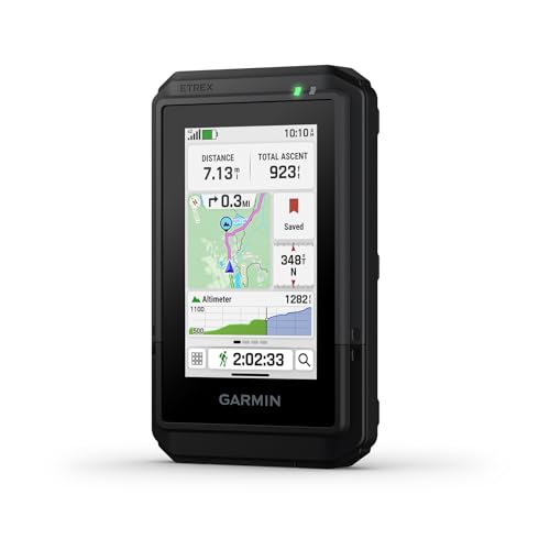
Garmin’s eTrex Touch blends ruggedness with a user-friendly color touchscreen and preloaded maps featuring roads and trails. The device offers topographic context with contours and outdoor landmarks, making it a solid value pick for hikers who want intuitive navigation on a reliable platform. The option to purchase an Outdoor Maps+ plan provides access to premium map content when needed. Best for hikers who prioritize brand reliability and straightforward operation, with a note that premium maps may require additional cost or subscription.
Spot Gen 4 Satellite GPS Messenger

Spot Gen4 is designed for adventure beyond cellphone coverage. It uses Globalstar satellite communication to transmit GPS coordinates and location updates, with a dedicated SOS feature for emergencies and tracking for ongoing movement. This device is best for hikers, campers, and families who need a reliable line of communication in remote areas. A caution: satellite-based devices require a subscription for full functionality, and response times can vary by satellite coverage and terrain.
Buying Guide: How to Choose the Right Value Hiking GPS
- What kind of terrain do you hike most often? If you frequently navigate in dense forests or backcountry, prioritize multi-GNSS support and a robust barometric altimeter for elevation awareness.
- How important is map detail versus battery life? If you rely on prekloaded topo or road maps, devices with preloaded maps (and expandable storage) are advantageous. For longer trips, battery life becomes the decisive factor.
- Display size and readability in bright settings matter. A sunlight-readable screen and intuitive button layout help you navigate quickly without stopping to inspect the map.
- Weight and form factor influence pack comfort. Smaller, lighter devices are ideal for day trips, while rugged, feature-rich units suit multi-day treks with heavier packs.
- Future-proofing through updates. Some brands offer lifetime or periodic map updates; consider whether you want to invest in optional map subscriptions.
- Bug-out readiness. For emergencies, consider devices with satellite communication (like Spot Gen 4) or those that integrate with emergency networks.
Quick Comparison by Use Case
- Best for budget-conscious hikers needing reliable GPS: NiesahYan Handheld GPS for Hiking or NiesahYan A6 model.
- Better for altimeter-focused routes and rough conditions: Ayayu Altimeter with barometer and multiple sensors.
- Choose this if you want large onboard map storage: S190 Handheld GPS Navigator with 64GB and USA Topo maps.
- Best brand reliability and user-friendly navigation: Garmin eTrex Touch.
- Avoid this if you require cellular connectivity: Spot Gen 4 relies on satellite communication rather than cell networks.
FAQ
- What is multi-GNSS and why does it matter for hiking?
Multi-GNSS means the device can use several satellite systems (GPS, Galileo, Beidou, QZSS) simultaneously, improving accuracy and reliability in challenging terrain or under tree canopies.
- Do these devices require internet?
Most handheld hikers’ GPS units function offline with preloaded maps. Some features, like map updates or cloud-connected map downloads, may require a connection.
- Is a larger display always better for hiking?
Not necessarily. A larger display improves map readability but adds weight. Many hikers prefer a balanced screen size with clear readability and long battery life.
- Can I save many waypoints?
Yes. Several models offer hundreds to thousands of waypoint slots, which is useful for marking campsites, trailheads, and landmarks.
- Is a dedicated altimeter important for hikes?
For climbs and high-elevation routes, an altimeter helps gauge elevation gain and track changes, pairing with a barometer for weather awareness.
- Do satellite messengers replace a GPS device?
Satellite messengers provide emergency communication and location sharing beyond cell coverage, but they are not navigation devices themselves. They complement GPS when traveling in remote areas.