For anglers seeking precise underwater views, side imaging sonar helps you locate fish, structures, and contours with clarity. This guide highlights top models with MEGA, Dual Spectrum CHIRP, and AutoChart features to boost efficiency on the water. Below is a quick summary table of the five featured products.
| Product | Brand | Imaging Highlights |
|---|---|---|
| Helix 7 G4 GPS Fish Finder with Transducer, MEGA Side Imaging | Humminbird | MEGA Side Imaging, Dual Spectrum CHIRP |
| XPLORE 9 GPS Fish Finder with Transducer, MEGA Side Imaging+ | Humminbird | MEGA Side Imaging+, MEGA Down Imaging+ |
| Helix 7 G4 GPS Fish Finder with Transducer, Dual Spectrum Chirp | Humminbird | CHIRP Down Imaging, Dual Spectrum CHIRP |
| Elite FS 9 Fish Finder with Active Imaging 3-in-1 | Lowrance | Active Imaging 3-in-1 (CHIRP, SideScan, DownScan), FishReveal |
| XPLORE 12 GPS Fish Finder, MEGA Side Imaging+ | Humminbird | MEGA Side Imaging+, MEGA Down Imaging+ |
Note: Each product offers a mix of side imaging, down imaging, and advanced mapping features. The selection focuses on models known for wide coverage, detailed target separation, and enhanced navigational charts suitable for American waters.
Humminbird Helix 7 G4 GPS: MEGA Side Imaging

The Helix 7 G4 GPS offers MEGA Side Imaging for expansive viewing on both sides of the vessel, plus MEGA Down Imaging for beneath the boat. Dual Spectrum CHIRP provides wide and narrow search modes, enabling fast coverage or detailed scanning. Its built-in Humminbird Basemap supports 10,000+ lakes and U.S. coastlines, with compatibility for LakeMaster, CoastMaster, and Navionics charts for enhanced navigation.
Humminbird XPLORE 9 GPS: MEGA Side Imaging+

XPLORE 9 combines MEGA Side Imaging+ with MEGA Down Imaging+ to reveal structures and fish in unprecedented detail, with Dual Spectrum CHIRP offering wide and narrow modes. The unit includes a robust GPS basemap of over 10,000 lakes and options for LakeMaster, CoastMaster, and Navionics charts. Real-time mapping features help anglers map depth contours, bottom hardness, and vegetation as they fish, and eight hours of built-in recording support extended data reviews.
Humminbird Helix 7 G4 GPS: Dual Spectrum Chirp

This Helix 7 G4 variant emphasizes CHIRP Down Imaging to filter noise and clutter, delivering clearer images beneath the boat. The Dual Spectrum CHIRP Sonar provides two modes for broad coverage or precise scanning, aided by a Low-Q transducer for strong 2D target separation. It ships with an enhanced Humminbird Basemap and full compatibility with premium charts to support detailed navigation across broad U.S. coastlines and inland waters.
Lowrance Elite FS 9: Active Imaging 3-in-1
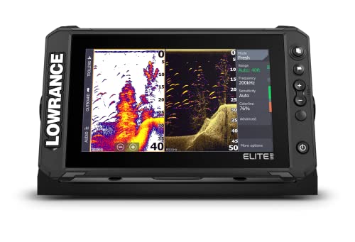
Lowrance Elite FS 9 introduces Active Imaging 3-in-1, combining CHIRP, SideScan, and DownScan with FishReveal for clearer fish-holding structures. An optional S3100 module enables Active Imaging HD for higher resolution. The system supports full networking with wireless, NMEA 2000, and Ethernet, allowing data sharing across displays and compatibility with Halo Dome Radar and other peripherals for a complete boat-wide sonar and navigation setup.
Humminbird XPLORE 10 GPS: MEGA Side Imaging+

XPLORE 10 builds on MEGA Side Imaging+ with 200-foot range on each side and MEGA Down Imaging+ for deep-water clarity. Dual Spectrum CHIRP enables flexible scanning, while built-in GPS Basemap with 10,000+ lakes and regional map cards supports extensive US and Canada navigation. AutoChart Live lets anglers create real-time maps of depth contours, bottom hardness, and vegetation, with eight hours of onboard recording for later analysis.
Buying Guide
- Imaging range and clarity: Choose models offering MEGA Side Imaging or MEGA Side Imaging+ for broader coverage, or Down Imaging for vertical detail beneath the hull.
- Charting and mapping: Look for Basemap coverage, compatibility with LakeMaster or Navionics, and AutoChart Live or AutoChart features to generate custom depth contours and vegetation maps.
- Search modes and resolution: Dual Spectrum CHIRP with wide and narrow modes improves target separation; consider models with CHIRP Down Imaging for clearer bottom views.
- Transducer options: Verify that a transducer is included or available; higher-end systems may require modular transducers for optimal MEGA imaging.
- Networking and expandability: For larger boats, prioritize units that support ethernet, NMEA 2000, and sharing across multiple displays; add-ons like Halo Radar or additional sonars can extend capabilities.
- User interface and screen size: Larger HD touchscreens simplify map reading and live sonar interpretation; consider waterproofing and glare resistance for sunny conditions.
- Marine chart ecosystems: Ensure compatibility with preferred chart providers (Navionics, LakeMaster, CoastMaster) for accurate coastal and inland navigation.
- Real-time mapping and logging: AutoChart Live or similar features help build and revisit hotspots; assess onboard storage if eight-hour or longer recordings are important.
In evaluating these side imaging fish finders, consider your typical fishing waters, boat size, and whether you prioritize wide area coverage or deep-water detail. Systems with MEGA imaging generally deliver higher detail at greater distances, while CHIRP-based sonar enhances target separation even in cluttered structures. A robust mapping and networking setup can significantly improve long-term fishing planning and efficiency on American lakes and coasts.