Finding the right GPS for UTV trail riding means prioritizing rugged durability, preloaded off-road maps, and reliable turn-by-turn guidance across mixed terrain. The following selections emphasize hard-wearing builds, open-source map data, and satellite imagery to help riders stay on track in forests, deserts, and remote backcountry. Below are five top options chosen for their relevance to UTV adventures and their strong feature sets for off-road navigation.
Summary of Selected Products
| Product | Brand | Display | Key Features |
|---|---|---|---|
| Garmin Tread Powersport Off-Road Navigator | Garmin | 5.5″ | IPX7, topo maps, BirdEye imagery, public/private land data, MVUM |
| Garmin Tread 2 – SxS Edition | Garmin | 8″ | OpenStreetMap trail routing, MVUM, private/public land info, elevation maps |
| Garmin Tread 2 – Overland Edition | Garmin | 8″ | Topographic maps, private/public land info, campgrounds, Street Navigator maps |
| Garmin zūmo XT | Garmin | 5.5″ | Ultrabright display, BirdsEye imagery, on-road/off-road maps, rugged build |
| Garmin Tread Overland | Garmin | 8″ | OSM/USFS MVUM, private/public land data, city navigator maps |
Garmin Tread Powersport Off-Road Navigator

The Garmin Tread Powersport Off-Road Navigator is built for harsh riding environments with IPX7 weather resistance and a 5.5-inch glove-friendly, ultrabright touchscreen. It ships preloaded with topographic maps for North and Central America, plus street maps and U.S. public/private land boundaries. It includes U.S. Forest Service roads and trails with Motor Vehicle Use Maps and BirdsEye Satellite Imagery that downloads without a subscription. A powered mounting system keeps the unit secure on a powersport vehicle, offering quick access on muddy or rocky trails.
Designed for off-road adventures, this device emphasizes reliable route guidance across varied terrain. While it excels in rugged environments, users should verify trail restrictions and local access rules before traveling. The combination of topographic data and land boundaries helps riders plan routes around sensitive areas while staying within legal guidelines.
Garmin Tread 2 – SxS Edition
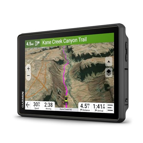
The Tread 2 SxS Edition features an 8-inch high-resolution, ultrabright touchscreen designed for extreme temperatures and weather (IP67). It provides turn-by-turn trail navigation for unpaved roads using OpenStreetMap data, plus Motor Vehicle Use Maps from the U.S. Forest Service and dedicated Adventure Roads and Trails map content. It also includes high-definition digital elevation maps, private/public land information, campgrounds, and snow trails, making it a strong choice for complex, multi-terrain rides. Data accuracy varies by area; always heed posted signs and conditions while riding.
Riders should consider whether they need broader city routing with City Navigator data or strict off-road routing. While the OpenStreetMap data is helpful, it should supplement, not replace, official trail and road guidance. The device balances robust off-road capabilities with practical on-road reuse for mixed trips.
Garmin Tread 2 – Overland Edition

The Tread 2 Overland Edition is built for off-grid expeditions with an 8-inch ultrabright, glove-friendly display and IP67 rating. It offers turn-by-turn trail navigation on unpaved roads and trails via OpenStreetMap and MVUM data, plus Adventure Roads and Trails maps. It includes detailed topographic maps of North and South America and private/public land information, along with campgrounds and snow trails. It also integrates City Navigator maps to support street routing appropriate for larger vehicles.
Consider if you frequently venture far from paved routes or rely on high-detail topography to anticipate elevation changes. The Overland Edition blends robust off-road mapping with street routing, which helps in mixed-use trips where you might return to highways or seek urban access points between backcountry sections.
Garmin zūmo XT
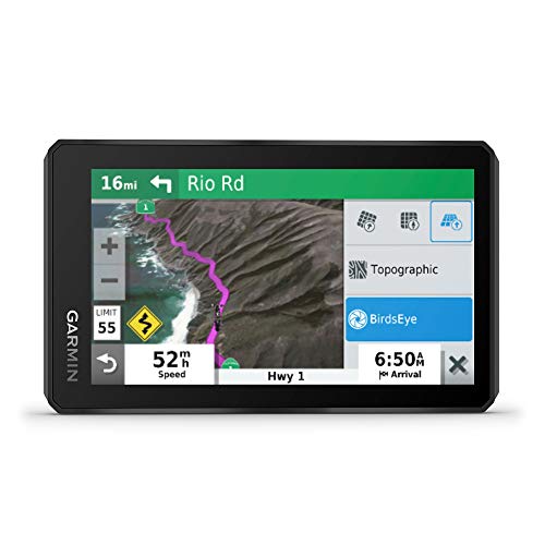
The zūmo XT is a rugged all-terrain navigation device designed for motorcycles and off-road use. It features a 5.5-inch ultrabright touchscreen with rain resistance and a durable build that meets military-grade standards. It offers spoken turn-by-turn directions via helmet or headset, plus preloaded off-road topographic maps with public land boundaries and 4×4 roads. BirdsEye Satellite Imagery can be downloaded directly to the device without an annual subscription, enabling enhanced situational awareness on challenging routes. It’s a compact option with strong off-road capabilities for trail riding on smaller rigs or side-by-sides.
Users should balance screen size with visibility on bright days and consider whether a larger display or multi-rig compatibility is needed for their typical rides. The zūmo XT excels in portability and weather resistance, making it a practical choice for riders who prefer a lighter, single-device solution for mixed terrain.
Garmin Tread Overland

The Garmin Tread Overland is an all-terrain navigator designed for rugged expeditions, with an 8-inch ultrabright display and built-in mapping. It includes an adjustable lock-in magnet-assisted mount for securing in your rig and turn-by-turn navigation for unpaved roads and trails via Adventure Roads and Trails maps. The device leverages OSM and USFS MVUM data, plus City Navigator maps for custom street routing that accounts for vehicle size and weight. It’s aimed at overland travelers who need reliable, durable, and comprehensive navigation across mixed surfaces.
When evaluating this model, assess how often you rely on city routing versus pure off-road navigation. The Overland edition emphasizes versatility by combining topographic detail and street routing, helping drivers plan multi-day routes that balance backcountry exploration with road travel.
Buying Guide: Key Purchase Considerations
- Durability and weather sealing: Look for IP ratings (IP67, IPX7) and rugged certification to withstand dust, water, and temperature extremes common on trail rides.
- Display quality and usability: Consider screen size, brightness, glove-friendly controls, and readability in direct sunlight; bigger displays help when mounted on a UTV or ATV cockpit.
- Mapping and data: Preloaded topographic maps, public/private land boundaries, USFS Motor Vehicle Use Maps (MVUM), and BirdsEye imagery provide essential context for trail planning and safety.
- Trail data sources: OpenStreetMap content and Adventure Roads and Trails offer versatile off-road routing, but verify data limitations and cross-check with posted signs and official road conditions.
- Mounting and power: A secure mounting system and reliable power connection are critical for long rides; check for weatherproof connections and compatibility with your vehicle’s power system.
- Battery life and expansion: Consider battery capacity, ability to add portable power banks, and whether the unit supports downloadable offline maps for areas with limited connectivity.
- Additional features: Elevation profiles, compass, barometer, and pitch/roll gauges can aid navigation across steep or tricky terrain; BirdsEye Satellite Imagery provides situational awareness when data is offline.
- Safety and compliance: Always adhere to local trail restrictions, land-use regulations, and posted signage; navigation devices are aids, not substitutes for on-trail awareness.
In conclusion, selecting a GPS for UTV trail riding hinges on balancing rugged hardware with rich off-road mapping and reliable route guidance. The options above cover a spectrum from compact, rugged units to larger, feature-rich displays, helping riders tailor a device to their typical trails, weather conditions, and maintenance preferences. Always pair your GPS with proper training, updated map data, and responsible riding practices to maximize safety and enjoyment on the trail.