Choosing the right GPS for off-road use means balancing rugged durability with accurate mapping, reliable satellite reception, and navigational features that handle backcountry trails. The following five Garmin models and one bundle offer a range of screen sizes, maps, and connectivity options to suit vehicles from side-by-sides to dirt bikes and ATVs. This guide compares their core capabilities to help you pick a device built for challenging terrain and remote locations.
| Product | Display | Maps & Data | Unique Strength |
|---|---|---|---|
| Garmin Tread Powersport Navigator | 5.5″ | Topographic North America, public/private land, Forest Service roads | Hazard-ready for powersports |
| Garmin Tread Powersport Navigator (Group Ride) | 5.5″ | Topographic & street maps, group tracking | Group communication and tracking |
| Garmin Tread 2 | 6″ | OpenStreetMap trails, Motor Vehicle Use Maps | All-terrain reliability |
| Garmin Montana 700 | 5″ | Multi-GNSS, TopoActive maps | Rugged MIL-STD 810, versatile mounting |
| Garmin zūmo XT | 5.5″ | Off-road topo maps, BirdEye Satellite Imagery | Helmet-friendly directions and imagery |
Garmin Tread Powersport Off-Road Navigator

The Tread Powersport Navigator is built for rugged off-road adventures. Its 5.5-inch touchscreen is glove-friendly and highly legible, with an IPX7 weather rating for wet conditions. It comes preloaded with topographic maps of North and Central America and street maps for North America, plus U.S. public and private land boundaries and Forest Service roads and trails with Motor Vehicle Use Maps. BirdsEye Satellite Imagery downloads are subscription-free, expanding field views without ongoing costs. A powered mount and wiring harness keep the device secured to a powersport vehicle, ensuring ease of use in rough terrain.
Key mapping and data layers support off-road navigation from snowmobile trails to forest roads. Users can plan routes using topographic detail and terrain-aware data, while forest and land boundaries help drivers avoid restricted areas. The durable construction and straightforward interface make it a popular choice for ATV and dirt bike riders who need reliable navigation in remote regions.
Garmin Tread Powersport Navigator With Group Ride
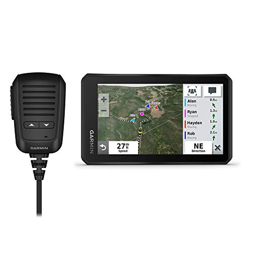
This variant adds Group Ride Radio connectivity, enabling push-to-talk and group tracking for up to 20 riders. The 5.5-inch display remains glove-friendly and ultrabright for daylight visibility. Along with preloaded topographic and street maps of North America, users gain access to public land boundaries and U.S. Forest Service roads. The BirdsEye Satellite Imagery option is available for download, offering enhanced situational awareness when choosing routes through off-road terrains or backcountry routes, making it a strong option for coordinated group rides and convoy navigation.
Group tracking and voice communication streamline coordination during collaborative trips or rescue scenarios. The combination of robust maps, trail data, and group features supports safer navigation in remote areas where phone coverage is limited. This model suits off-road enthusiasts who ride with multiple vehicles or guides who need to maintain contact over rugged routes.
Garmin eTrex 22x

The eTrex 22x is a compact handheld GPS navigator designed for rugged use in outdoor settings. Its 2.2-inch, sunlight-readable color display provides clear readability in various lighting conditions. It ships preloaded with Topo Active maps featuring routable roads and trails tailored for cycling and hiking, making it a versatile choice for hikers and off-road travelers who want a lighter, more portable device. While smaller than the Tread series, the 22x benefits from long battery life and reliable GPS performance in remote areas where satellite visibility can be challenging.
For users prioritizing portability without sacrificing essential mapping, the eTrex 22x offers a dependable solution. It complements larger navigators by providing a spare device option or a secondary backup with easy access to topographic data in the field. Note its strength is mobility and battery efficiency rather than full-featured powersport integration.
Garmin Tread 2 Powersport Navigator

The Tread 2 builds on Garmin’s robust powersport platform with a 6-inch glove-friendly, ultrabright touchscreen designed to withstand extreme weather (IP67). It provides turn-by-turn trail navigation for unpaved roads and trails, including U.S. Forest Service Motor Vehicle Use Maps and Adventure Roads and Trails content. In addition to topographic detail, it integrates high-definition digital elevation maps and data about private and public land, campsites, and snow trails. It also supports on-road routing with City Navigator maps, offering interchange between off-road adventures and paved routes.
With its larger display and comprehensive terrain data, the Tread 2 is well-suited for riders who demand depth in mountain trails or desert crossings. The device balances on-highway efficiency with off-road exploration, providing reliable navigation in challenging environments while maintaining a straightforward user experience for quick route adjustments in the field.
Garmin Montana 700

The Montana 700 is a rugged handheld GPS with MIL-STD 810 protection for temperature, shock, water, and vibration. Its 5-inch glove-friendly color touchscreen is larger than the eTrex line, and it supports versatile mounting options for vehicles, backpacks, or boats. Featuring Multi-GNSS (GPS, GLONASS, and Galileo) support, it ships with preloaded TopoActive maps and includes outdoor navigation sensors such as a 3-axis compass and barometric altimeter. This device targets off-road explorers who require robust hardware, precise topography, and reliable satellite reception in extreme environments.
The Montana 700’s balance of near-mobile portability and rugged capabilities makes it suitable for a wide range of outdoor activities, from overland expeditions to hunting trips. It stands out for users who want a resilient handheld that can endure harsh conditions without compromising map detail or satellite performance, even when signals are partially obstructed.
Garmin zūmo XT
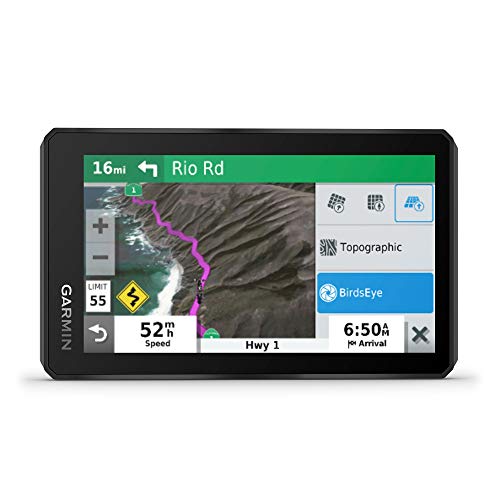
The zūmo XT is an all-terrain motorcycle-friendly navigation device with a 5.5-inch ultrabright display that remains readable in direct sunlight. Its rugged build meets military-grade durability, and it supports Birdseye Satellite imagery downloads for offline viewing. The device provides spoken turn-by-turn directions through connected helmets and preloaded off-road topographic maps that include public land boundaries and 4×4 roads. This model is designed for motorcyclists and riders who require side-by-side navigation with outdoor imagery and robust on-device mapping without ongoing subscriptions for base satellite imagery.
With its glove-friendly controls and flexible mounting options, the zūmo XT offers a balance between on-road reliability and off-road explorations. Its emphasis on weather resistance and image-based situational awareness makes it a strong option for riders who traverse mixed terrains and want quick access to detailed terrain data and satellite views on the trail.
Garmin Tread Overland 8” Bundle

The Tread Overland 8-inch bundle combines a large, high-visibility display with rugged construction and advanced navigation aids. It includes a suction cup mount, vehicle power cable, locking magnet-assisted mount, USB cable, and a PlayBetter portable charger. The Overland edition emphasizes built-in altimeter, barometer, compass, and pitch/roll gauges to help navigate challenging terrain. It ships preloaded with topography and BirdsEye imagery, iOverlander points of interest, and Ultimate Public Campgrounds data for overland expeditions. This bundle is aimed at adventurers who require an all-in-one, reputable navigation suite for extended expeditions and vehicle-based exploration.
For off-road explorers who cover long distances or remote areas, this setup offers enhanced situational awareness and energy flexibility. The large 8-inch display improves readability in bright environments, while the integrated sensors support safer navigation over varied terrain and weather conditions. The bundle’s accessories add mounting stability and power resilience for multi-day trips.
Buying Guide
Key purchase considerations for off-road GPS devices include display size and readability, ruggedness and water/dust resistance, mapping depth, and satellite data availability. Larger screens offer easier map reading and route planning under bright sun, but may add bulk. Garmin’s Tread line focuses on powersport use, with features like Forest Service roads, public land boundaries, and BirdsEye imagery, while Montana and Montana-based devices emphasize extreme durability and multi-GNSS support for harsh environments. For group rides or expeditions, look for devices with group tracking and communication capabilities to maintain coordination.
Map content matters: preloaded topo and satellite imagery provide context when signals fail, but consider whether you need subscription-free imagery or optional updates. Battery life and mounting versatility influence field performance; a device with a reliable battery and secure, weatherproof mounting reduces downtime during remote excursions. Interface simplicity and glove-friendly controls improve safety on moving vehicles. Finally, evaluate whether you want a dedicated powersport navigator or a multi-sport handheld that can double as a hiking or cycling tool when not on a trail.