Answering the buyer’s intent: These fish finders emphasize down imaging to reveal fish, structures, and contours directly beneath the boat. They’re best for anglers who want precise, detailed views of what lies below and around their vessel, especially in structured waters or murky conditions. The top picks vary in screen size, processing power, and map features, but all focus on down imaging clarity to help with target identification and scouting.
Summary table of selected products:
| Product | Down Imaging Strength | Navigation & Maps | Best For |
|---|---|---|---|
| Humminbird HELIX 7 G4N GPS Fish Finder | MEGA Down Imaging | Basemap, 10,000+ lakes, coastlines | Anglers who want detailed under-boat views with solid navigation |
| Humminbird XPLORE 10 GPS Fish Finder | MEGA Down Imaging+ (up to 200 ft) | Basemap + LakeMaster/CoastMaster | Those wanting broad imaging and real-time mapping |
| Humminbird 411590-1 Helix 7 Chirp SI GPS G4 | Down Imaging + Side Imaging | CHIRP maps and pre-loaded views | Versatile imaging with 2D/side views |
| Humminbird XPLORE 9 GPS Fish Finder | MEGA Down Imaging+ (up to 200 ft) | Basemap + optional map cards | Compact, feature-rich down imaging |
| Humminbird XPLORE 12 GPS Fish Finder with Transducer | MEGA Down Imaging+ (up to 200 ft) | Basemap + LakeMaster/CoastMaster VX; Navionics compatibility | Large screen with deep imaging and real-time mapping |
Humminbird HELIX 7 G4N GPS Fish Finder with MEGA Down Imaging
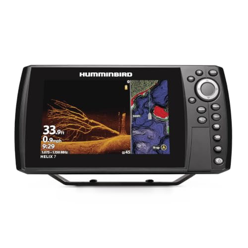
MEGA Down Imaging Technology reveals underwater details up to 125 feet directly beneath the boat with three times more detail than standard imaging sonar. This control head-only unit relies on a separate transducer. It delivers Dual Spectrum CHIRP sonar for wide and narrow search modes, helping locate fish arches and holding structures. Enhanced GPS navigation uses Humminbird Basemap with coverage of over 10,000 lakes and U.S. coastlines, and compatibility with LakeMaster, CoastMaster, and Navionics charts. Best for anglers who want deep, precise under-boat imaging and reliable charting in familiar waters.
Best for: anglers needing strong down-imaging performance in a compact display, paired with robust mapping options. Caution: transducer not included, so plan for a compatible transducer installation.
Humminbird XPLORE 10 GPS Fish Finder

This model features MEGA Side Imaging+ with a 200-foot range on each side and MEGA Down Imaging+ with 200-foot depth coverage, plus Dual Spectrum CHIRP for clear fish and structure visibility. It’s a control head-only unit, so you’ll need a transducer separately. On navigation, it provides built-in GPS with Basemap for over 10,000 lakes and coastlines, and includes LakeMaster and CoastMaster VX cards for US and Canada. AutoChart Live lets you map fishing spots in real time, and eight hours of built-in recording enhance post-trip analysis.
Best for: anglers seeking expansive down imaging combined with strong side imaging, and who want extensive real-time mapping capabilities. Choose this if you want real-time mapping alongside broad imaging coverage. Limitation: transducer must be purchased separately.
Humminbird 411590-1 Helix 7 Chirp SI GPS G4

Keypad control enables quick access to pre-loaded views via a user-friendly menu, and the unit offers CHIRP Side Imaging for left and right views and CHIRP Down Imaging for detailed views beneath the boat. This model emphasizes clean imaging with CHIRP Digital Sonar processing on both sides and below, ensuring clearer target separation and structure visibility. Best for: anglers who want reliable, easy access to side and down imaging in a mid-size unit. Caution: interface relies on keypad controls which may require some familiarity.
Humminbird XPLORE 9 GPS Fish Finder

Equipped with MEGA Side Imaging+ and MEGA Down Imaging+ up to 200 feet, this model also includes Dual Spectrum CHIRP for enhanced fish and structure clarity. It features built-in GPS with Basemap covering 10,000+ lakes and coastal waters, plus map cards for expanded regions. AutoChart Live creates real-time maps of spots, including depth contours and vegetation, and eight hours of recording time supports post-trip analysis. Best for: anglers seeking a balance of detailed down imaging and broad mapping in a compact 9-inch screen. Limitation: control head-only configuration requires a separate transducer.
Humminbird XPLORE 12 GPS Fish Finder with Transducer

This 12-inch model combines MEGA Side Imaging+ with 200-foot range per side and MEGA Down Imaging+ reaching 200 feet, plus Dual Spectrum CHIRP sonar for detailed detection. It ships with an advanced GPS Basemap featuring 10,000+ lakes and coastlines, and includes LakeMaster and CoastMaster VX cards. AutoChart Live supports real-time depth contours, bottom hardness, and vegetation mapping, with eight hours of built-in recording time and compatibility with Navionics charts. Best for: large-screen lovers who want comprehensive imaging and mapping in one package. Caution: larger footprint, which may require more installation space.
Buying Guide
What to consider when choosing a down imaging fish finder:
- Imaging depth and clarity: Look for MEGA Down Imaging or Down Imaging+ for the clearest view directly below and around the boat.
- Display size and readability: Larger screens improve detail in cluttered water; consider mounting space and visibility in sunlight.
- Transducer needs: Many “control head only” units require a compatible transducer; plan for installation and mounting.
- Mapping and chart options: Basemap coverage plus LakeMaster/CoastMaster or Navionics compatibility expands navigational safety and fishing potential.
- Storage and real-time mapping: AutoChart Live and built-in recording time help capture fishing spots for later analysis.
- Extra features: Side Imaging, CHIRP modes, and compatibility with additional Sonar modules influence overall usefulness depending on hunting style.
FAQ
- What is MEGA Down Imaging?
MEGA Down Imaging provides higher detail directly beneath the boat, making it easier to identify fish, structures, and bottom contours. - Do control head-only units require a transducer?
Yes. Control head-only models need a separate transducer to send sonar signals into the water. - Is side imaging necessary for down imaging users?
It’s optional. Side imaging helps locate structures to the sides, which can complement down imaging for broader scouting. - What maps are most useful for freshwater fishing?
Basemap plus LakeMaster or Navionics cards offer detailed lake contours, depths, and navigational markers, depending on your region. - Can I upgrade the mapping later?
Many models support map cards or software updates; verify compatibility with your chosen system. - Which size screen should I choose?
Larger screens (9–12 inches) improve readability in bright or dynamic conditions, but fit and budget should be considered.